
Route San Antonio (Santiago), Chile - Herrliche Panoramablicke beim Reloncaví-Sund - Puerto Montt, Chile - Scenic Cruising Moraleda Channel - Scenic Cruising Darwin Channel - Scenic Cruising Baker Channel - Caleta Tortel, Chile - Transit The English Narrows - Scenic Cruising Eyre Fjord - Pio XI Glacier Mehr

This large, modern port serves Chile’s capital, Santiago, a city with Spanish colonial charm and a vivacious spirit. Encircled by the Andes and the Coastal Range, Santiago is centered around the Plaza de Armas, with several of the city’s landmarks: the 18th-century Metropolitan Cathedral the Palacio de la Real Audencia from 1808, the City Hall and the National Museum of History. North of San Antonio lie the picturesque old port and university town of Valparaíso and the colorful seaside resort of Viña del Mar. In between the coast and the capital are valleys filled with some of Chile’s most famous wineries, all inviting you to come and taste.
Puerto Montt, in Chile’s Northern Patagonia Los Lagos region is set on the shores of a large bay identified as Reloncavi Sound. To the east looms Mt. Yate, a snowcapped, glaciated stratovolcano, and beyond that the cordillera of the Andes. The sound is punctuated by islands, the three largest being Tengio, Maillén and Huar. Two much larger islands, Puluqiui and Queulín, sprawl across the mouth of the sound, separating it from the Gulf of Ancud. The point where the Reloncavi Estuary empties into the sound is effectively where the Chilean Central Valley meets the Pacific Ocean. Salmon farms dimple the coves of the sound, and pods of orcas are sometimes seen. Near the sound on shore, Chile’s Alerce Andino National Park protects a vestigial forest of ancient alerce trees, similar to the huge sequoias found in North America.
Das Seenland im südlichen Chile scheint nicht vom selben Stern zu sein wie die Wüsten des Nordens. Die Seen-Region bietet eine phantastische Landschaft, darunter der fabelhafte schneebedeckte Vulkankrater Mount Osorno. Puerto Montt ist für die Region der Haupthafen und dient außerdem als Ausgangspunkt für Seereisen zu den chilenischen Fjorden im Süden.
The Moraleda Channel is a protected waterway running along the coast of Chile from the Gulf of Corcovado in the north to the Laguna San Rafael in the south. It separates the myriad mountainous islands of the Chonos Archipelago from the Chilean mainland. Like the Inside Passage on the Pacific coast of North America, the Moraleda Channel is a geological feature. Its course follows the geologic Liguiñe-Ofqui Fault on the eastern side of the islands, which are actually the peaks of the submerged Chilean Coastal Range.
The Darwin Channel cuts through the elongated, mountainous islands of the Chonos Archipelago in Southern Chile, connecting the Pacific Ocean on the west with the Moraleda Channel running along the Chilean mainland. These forested islands, mostly uninhabited, are actually the peaks of the submerged Chilean Coastal Range. Darwin Channel is a westward continuation of the Aysén Fjord, connecting to the Pacific at Isquiliac Island, and opening at its eastern end into Darwin Bay. Being free of navigational hazards, it forms a preferred, scenic pathway for ships navigating in the area.
The Baker Channel is a large, multi-armed fjord that cuts from Tarn Bay in the Gulf of Penas some 75 miles into the Chilean mainland. It lies roughly halfway between the Northern and Southern Patagonian Ice Fields, and its southern arm culminates at the face of the Jorge Montt Glacier, which flows from the Southern ice field and frequently calves icebergs into the channel. The channel forms the northern boundary of Chile’s vast Bernardo O’Higgins National Park.
On the long Messier Channel between the huge Wellington island and the Chilean mainland, the English Narrows is a natural, eight-mile obstacle consisting of a scattering of islands constricting the passage to a width of as little as 200 yards. It presents no hazard to a skilled navigator under most conditions, but at spring tides the current runs as much as six knots, and wind conditions may also make navigation risky. The narrows transit is a good time to be on deck, to keep an eye out for birds such as diving petrels or steamer ducks, and possibly the small, rare dolphins that are sometimes seen in remote areas like this.
Eyre Fjord penetrates the mainland of southern Chile from the Icy Channel about 20 miles to the broad face of the massive Pio XI glacier, also known as the Brüggen Glacier. It is the longest glacier in the Southern Hemisphere outside Antarctica, flowing some 40 miles from the Southern Patagonian Ice Field to the fjord. It is also one of the very few advancing glaciers on earth. The glacier face is located near a large eastern arm of Eyre Fjord called Exmouth Fjord.
The Wide Channel is an inside passage along the coast of southern Chile. It separates the eastern lobe of the huge Wellington Island from the Chilean mainland, starting between Saumarez Island and Icy Channel in the north and opening into the Concepcion Channel in the south adjacent to the Bernardo O’Higgins National Park on the mainland Wilcock Peninsula. Surrounded by precipitous mountains, its shoreline on the mainland side is interrupted by two large fjords, the Europa and Penguin fjords. Join your expedition team members on deck or in an observation lounge for expert insights into the area.
Cutting eastward from the Sarmiento Channel in Southern Chile, this fjord divides into three separate fjords, called Amalia, Asia and Calvo Fjords. Amalia leads to Amalia Glacier, the El Brujo Glacier is in Asia Fjord, and Calvo boasts several small glaciers of its own. The mainland to the east is all part of the huge Torres del Paine National Park. The area is a fascinating geological panorama, and your expedition team members will be available to interpret the sights, as well as identify wildlife spotted while cruising the scenic waterways.
The Smyth Channel is another of the spectacular waterways threading the maze of islands off the coast of extreme southern Chile. At its northern end, it briefly parallels the Sarmiento Channel, then veers southward opening into the Strait of Magellan. Dotted with myriad small islands and corrugated with countless narrow fjords and bays, it makes a mesmerizing panorama as your ship plies between the islands on one side and the immense Peninsula Muñoz-Gamero on the other. Members of your expedition team will be on deck and in lounges to offer insights into the wild, unspoiled terrain you are passing.
Rote Dächer und rauchende Kamine zieren die sanfte Hügellandschaft von Punta Arenas („sandiger Ort“), das Zentrum einer der weltweit größten Schafzucht-Regionen. In dieser freundlichen Stadt erwarten Sie schöne Parks und großartige viktorianische Architektur.
Rote Dächer und rauchende Kamine zieren die sanfte Hügellandschaft von Punta Arenas („sandiger Ort“), das Zentrum einer der weltweit größten Schafzucht-Regionen. In dieser freundlichen Stadt erwarten Sie schöne Parks und großartige viktorianische Architektur.
Ushuaia ist die südlichste Stadt der Welt, die Hauptstadt der Provinz „Argentine Tierra del Fuego“ und außerdem ein wichtiger Marinestützpunkt. Besonders an den Gestaden der Ushuaia-Bucht und des Beagle-Kanals bieten sich dem Besucher grandiose Ansichten. Die charmante Kleinstadt an der Atlantikküste liegt malerisch eingebettet zwischen Wasserfällen, Gletschern, schneebedeckten Bergen und Birkenwäldern. Die Unterwasserwelt vor der Küste von Ushuaia wimmelt nur so vor den unterschiedlichsten Meeresbewohnern. Man darf sich nicht von den in warmen Pastellfarben gestrichenen Häusern täuschen lassen; tatsächlich ist es hier das ganze Jahr über ziemlich kalt, weshalb auch Wintersportarten wie Alpinskilauf, Langlauf und Schlittschuhlaufen sehr populär sind. Die bestimmenden Wirtschaftszweige in Ushuaia sind die Schafzucht, die Holzgewinnung, die Fischerei und das Fallenstellen. Eine größere Bevölkerungszunahme auf 30.000 Einwohner erfuhr die Stadt in den späten 1980ern, als die argentinische Regierung versuchte, die Region in Antarktis-Nähe dichter zu besiedeln. Als Anreiz wurden jenen, die sich dort niederließen, großzügige Steuererleichterungen gewährt.
Ushuaia ist die südlichste Stadt der Welt, die Hauptstadt der Provinz „Argentine Tierra del Fuego“ und außerdem ein wichtiger Marinestützpunkt. Besonders an den Gestaden der Ushuaia-Bucht und des Beagle-Kanals bieten sich dem Besucher grandiose Ansichten. Die charmante Kleinstadt an der Atlantikküste liegt malerisch eingebettet zwischen Wasserfällen, Gletschern, schneebedeckten Bergen und Birkenwäldern. Die Unterwasserwelt vor der Küste von Ushuaia wimmelt nur so vor den unterschiedlichsten Meeresbewohnern. Man darf sich nicht von den in warmen Pastellfarben gestrichenen Häusern täuschen lassen; tatsächlich ist es hier das ganze Jahr über ziemlich kalt, weshalb auch Wintersportarten wie Alpinskilauf, Langlauf und Schlittschuhlaufen sehr populär sind. Die bestimmenden Wirtschaftszweige in Ushuaia sind die Schafzucht, die Holzgewinnung, die Fischerei und das Fallenstellen. Eine größere Bevölkerungszunahme auf 30.000 Einwohner erfuhr die Stadt in den späten 1980ern, als die argentinische Regierung versuchte, die Region in Antarktis-Nähe dichter zu besiedeln. Als Anreiz wurden jenen, die sich dort niederließen, großzügige Steuererleichterungen gewährt.
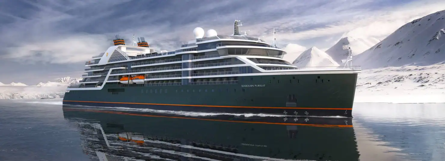
18 Nächte mit der Seabourn Pursuit - - Abfahrt 18.10.2027
![]()

![]()
Vielen Dank für Ihre Anfrage. Sie werden von uns so schnell wie möglich eine entsprechende Offerte erhalten. Beste Grüsse Ihr Cruisetour-Team